You never quite know when a question will be answered.
Case in point: Lieutenant Ernest Willy Rosenstein, a South African Spitfire pilot in No. 185 (and earlier No. 242) Squadron, Royal Air Force, and the only child of German nine-victory World War One ace Leutnant d.R. Willy Rosenstein. Killed in action in north central Italy almost a month prior to the the Second World War’s end, two aspects of his final combat mission, described in my 2018 post Soldiers from New York: A Spitfire in April – Ernest Willy Rosenstein – II, have remained a mystery.
Where was he shot down?
Where did his Spitfire fall to earth?
Part of this uncertainty arose from a letter received some years ago from the Air Historical Branch of the Ministry of Defence (Lacon House Theobald’s Road) concerning Ernest Willy’s last mission:
“Our records show that Lieutenant Rosenstein was the pilot of Spitfire MH892 which was on an air operation (dive bombing) of a methane gas plant at Fontana at about 1100 hours on the day in question. His aircraft was seen to crash just west of the target.
“Lieutenant Rosenstein was badly injured on the crash and he died in the local hospital a few hours later. He was originally buried in a local cemetery, but after the war he was buried in a British Military Plot in a cemetery in Milan.
“Eyewitnesses stated that Lieutenant Rosenstein made a last-minute attempt to bail out, but apparently he was too low for his parachute to deploy properly.”
Where was (where is) Fontana? I couldn’t find it on a map, whether print or digital.
Similarly, the Squadron Summary of Events for No. 185 Squadron for the April 2 mission notes: “Six Spitfires led by P/O L. Liversidge attacked METHANE Gas Plant at P.973903. Bombed Compressor filling station scoring one direct hit and two near misses. Compressor building was severely damaged. Twenty-five strafing runs were made and numerous strikes were scored. One aircraft piloted by Lt. E.W. Rosenstein burst into flame at the beginning of its bombing dive and dived straight into the ground and exploded. No parachute was seen and no flak was observed.”
Where was (where is) “Fontana”?
Where was (what is) “P.973903”? Is this even on a map?
So now in 2021, three years after the initial posts about Lt. Rosenstein, I’ve found – or more accurately, I’ve received – the answers to these questions. They arrived from researcher Rolland Swank, who was also instrumental in providing me with information pertaining to Corporal Jack Bartman, a member of the United States Air Force who was murdered after being captured near the Tyrolean Alps, on April 20, 1945.
Thanks again, Rolland!
____________________
Here are the two communications I received from Rolland concerning Ernest Willy Rosenstein’s last mission. Within this information lies the “key” to the mystery: There was (is) no village of “Fontane“, but there most certainly was (is) a village of “Fontana“.
Regarding the crash site for Ernest Willy Rosenstein. The co-ordinates given in the squadron records is P.973903. This is a location in the North Italy Zone. An explanation for the mapping system is here.
The full co-ordinates would be vP973903 (North Italy Zone). This translates to 44° 50′ 15” N, 10° 10′ 00” E.
On Google maps it is here.
You can see on the map that “Fontane” is just to the North East.
Another clue to the location of the crash is to look a where he was first buried. Here is the link to information about his grave.
If you click on the “Concentration (1)” tab (link also here) – and look at the “Previously Buried at” column, you will see he was first buried in the Civil Cemetery Noceto. Noceto is a town located about a mile or so south of the crash site.
__________
The echodelta.net website for map locations can be off somewhat as to exact locations. They note (because of the math they use) sometimes locations can be off by 150 to 1000 meters. However, you can look at the actual maps that they were using in Italy at the time. Here is such a map with the grid system. It shows Fontane in the lower right corner.
It looks like vP973903 is actually a located about where the Via Emila and Str. Nuova (named on Google maps) intersect. Thus we should move the Red Google indicator 50 or so meters down and the 50 meters to the left. The map shows two “star” symbols on either side of Str. Nuova. A star symbol indicates a “Mill”. [Thus, finally, an answer: The location of vP973903 is in the village of Molinetto.]
__________
And so, using the places names, geographic coordinates, and maps provided by Rolland, I’ve been able to identify the probable location where Ernest’s fighter, Spitfire IX MH892, fell to earth. Using a combination of Oogle Map Views, Earth Views, and Street Views, this is illustrated below.
____________________
However, rather than fully recapitulate Ernest Willy’s life story “here” (the original post “A Spitfire in April – II” can be found here), here are a few images and excerpts from that original post, to place “this” post in a clearer context.
____________________
A formal portrait of Ernest Willy in his officer’s uniform.
.ת.נ.צ.ב.ה.
Tehé Nafshó Tzrurá Bitzrór Haḥayím
May his soul be bound up in the bond of everlasting life.

____________________
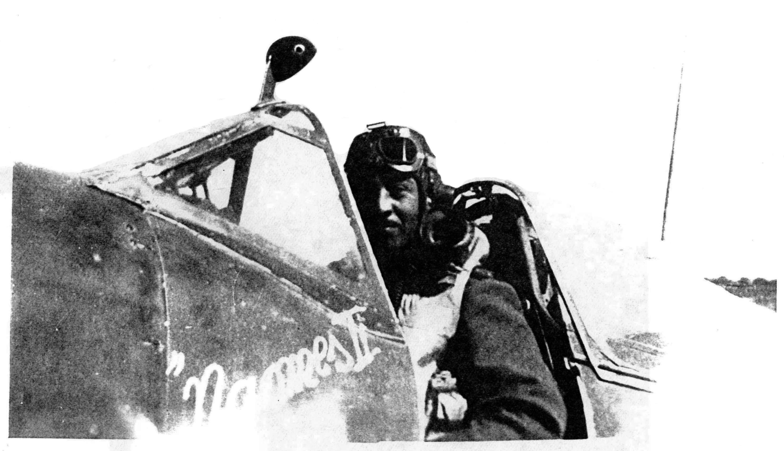
Ernest Willy, seated in the cockpit of Naomes II, a Spitfire IX which he flew while assigned to No. 242 squadron RAF. The aircraft carried the squadron code “LE * P”, buts its serial number is unknown. Based on information in Ernest Willy’s Pilot’s Log Book and other sources, the image can be dated to July through mid-August of 1944.
____________________
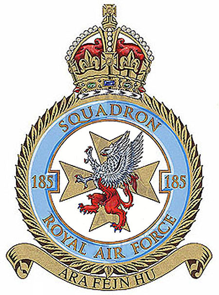
The insignia of Number 185 Squadron, Royal Air Force
“Ara Fejn Hu” is Maltese to the effect of “Look where it is” or “See where he is“
____________________
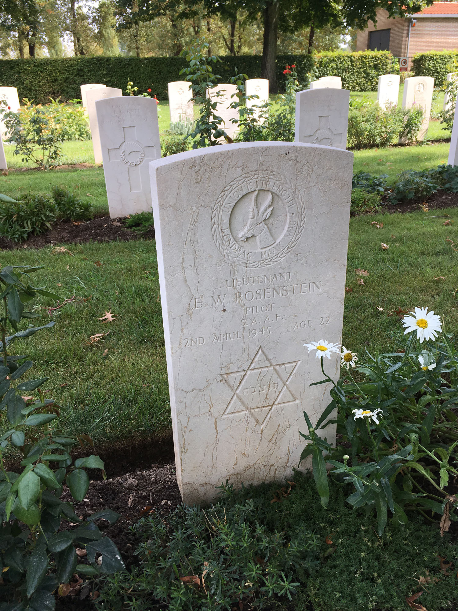
Ernest Willy’s matzeva at the Milan War Cemetery in Italy (plot location V, A, 5) photographed by FindaGrave contributor and76.
____________________
These two images, both via the National Archives, show No. 185 Squadron’s Summary of Events, and Operations Record Book (respectively) for 2 April, 1945.
“Six Spitfires led by P/O L. Liversidge attacked METHANE Gas Plant at P.973903. Bombed Compressor filling Station scoring one direct hit and two near misses. Compressor building was severely damaged. Twenty-five strafing runs were made and numerous strikes were scored. One aircraft piloted by Lt. E.W. Rosenstein burst into flame at the beginning of its bombing dive and dived straight into the ground and exploded. No parachute was seen and no flak was observed.”
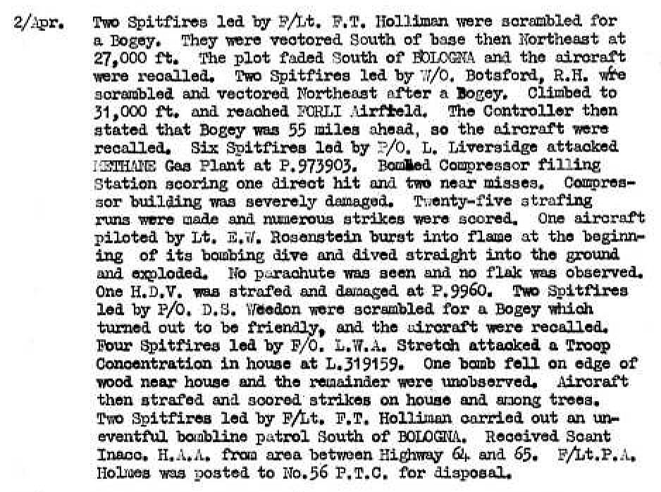
“Six Spitfires led by P/O L. Liversidge attacked METHANE Gas Plant at P.973903. Bombed Compressor filling station scoring one direct hit and two near misses. Compressor building was severely damaged. Twenty-five strafing runs were made and numerous strikes were scored. One aircraft piloted by Lt. E.W. Rosenstein burst into flame at the beginning of its bombing dive and dived straight into the ground and exploded. No parachute was seen and no flak was observed.”

____________________
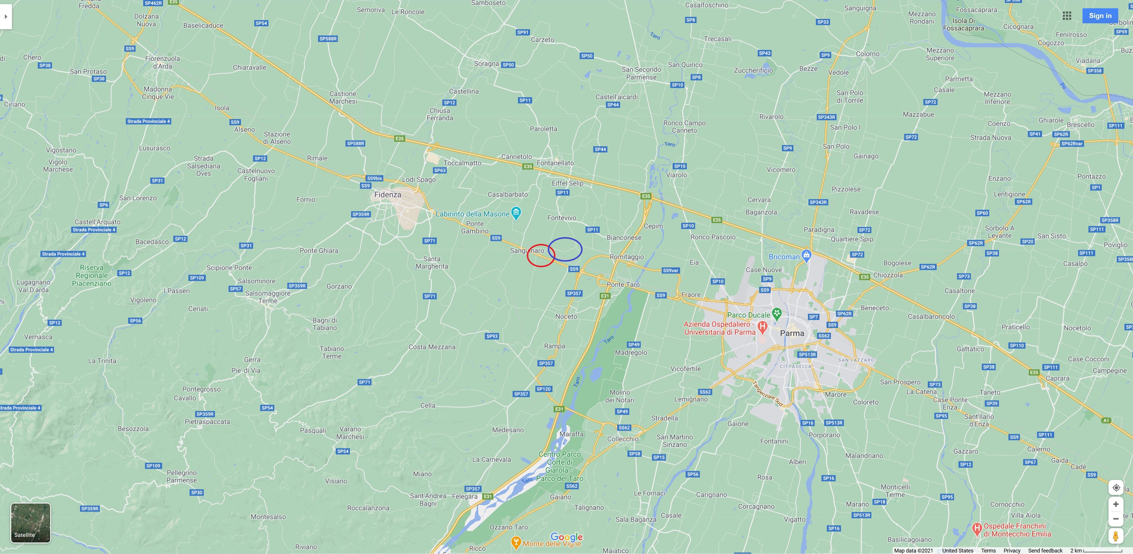
Here’s a small-scale Oogle Map showing Parma and Fidenza, with the position of Fontane circled in blue and Molinetto in red.
____________________
By way of comparison, here’s the United States Army Map Service 1944 (second edition) 1:50,000 map (Sheet 73-IV) of Fidenza, with the area of interest in the lower right corner. Though Fontane is labeled, Molinetto is not.
As mentioned by Roland, “The echodelta.net website for map locations can be off somewhat as to exact locations. They note (because of the math they use) sometimes locations can be off by 150 to 1000 meters. However, you can look at the actual maps that they were using in Italy at the time. Here is such a map with the grid system. It shows Fontane in the lower right corner.”

____________________
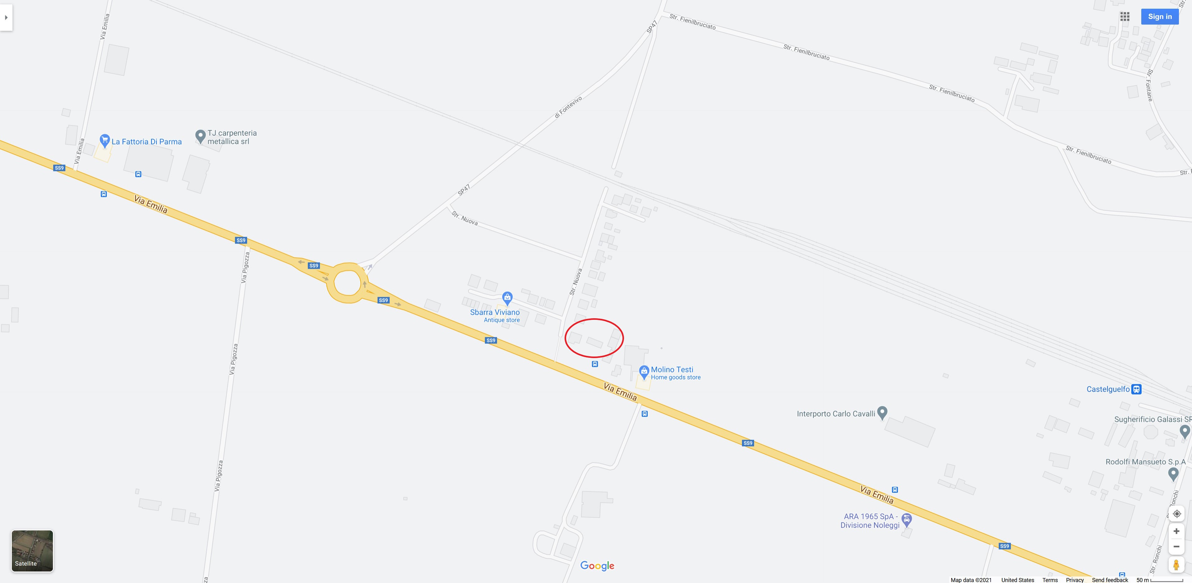
Moving in closer. Fontane is circled in blue, and the location of Molinetto in red. The six-pointed-star at Molinetto represents a (grain?) mill.

____________________
Here’s an Oogle map view of the same general area, showing the locations of Fontane and Molinetto, in blue and red respectively.

____________________
An Oogle Earth view of Fontane…

____________________
…and, an Oogle map showing the location of Molinetto.
____________________
An Oogle Earth view of Molinetto…

____________________
…and Oogling in for a even closer view of Molinetto.

____________________
Now, we move from aerial views to earthbound views.
This Oogle Street (highway?!) view looks west-northwest along Via Emilia (SS9), just before reaching the village of Molinetto. Beyond and behind the six Mulmix grain siloes (and therefore not visible in the image) lies the Molino Testi home goods store, at 77 Via Emilia.

____________________
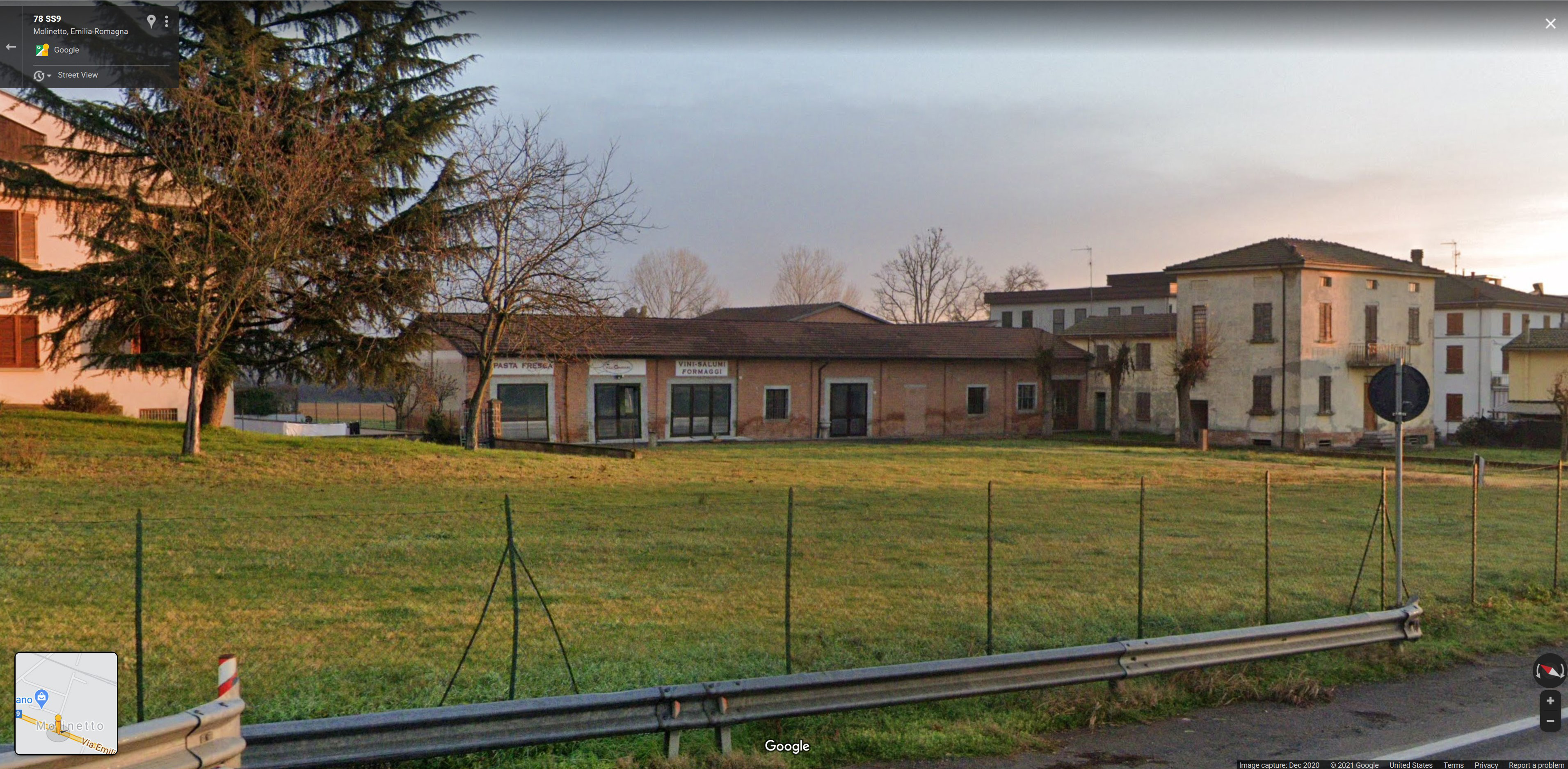
Having just driven past (virtually, that is) the six siloes and the Molino Testi store (both to the “right” of this image), we reach the Vini-Salumi Formaggi / Pasta Fresca (“Wines-Salami Cheeses / Fresh Pasta”) store, the one-story brick building in the center of this image. Though this particular screen-shot dates to 2020, recent (2021) Oogle Street views reveal that this building is vacant, and, completely absent of any signs of ownership. Albeit, it’s still private property.

____________________
Going a little farther along Via Emilia, here’s a closer 2020 view of the Vini-Salumi Formaggi / Pasta Fresca store.
____________________
We are now within Molinetto and on Str. Nuova, which is oriented north-northeast. In the center of this image, the Oogle Street View camera looks into a gravel access road or driveway between two apartment buildings. Looking closely, it can be seen that this access road leads to (and ends) directly at the rear of the former Vini-Salumi Formaggi. (Oogle Street and map views reveal that Str. Nuova cannot be reached by Via Emilia due to a fence at the intersection of these two roads.)
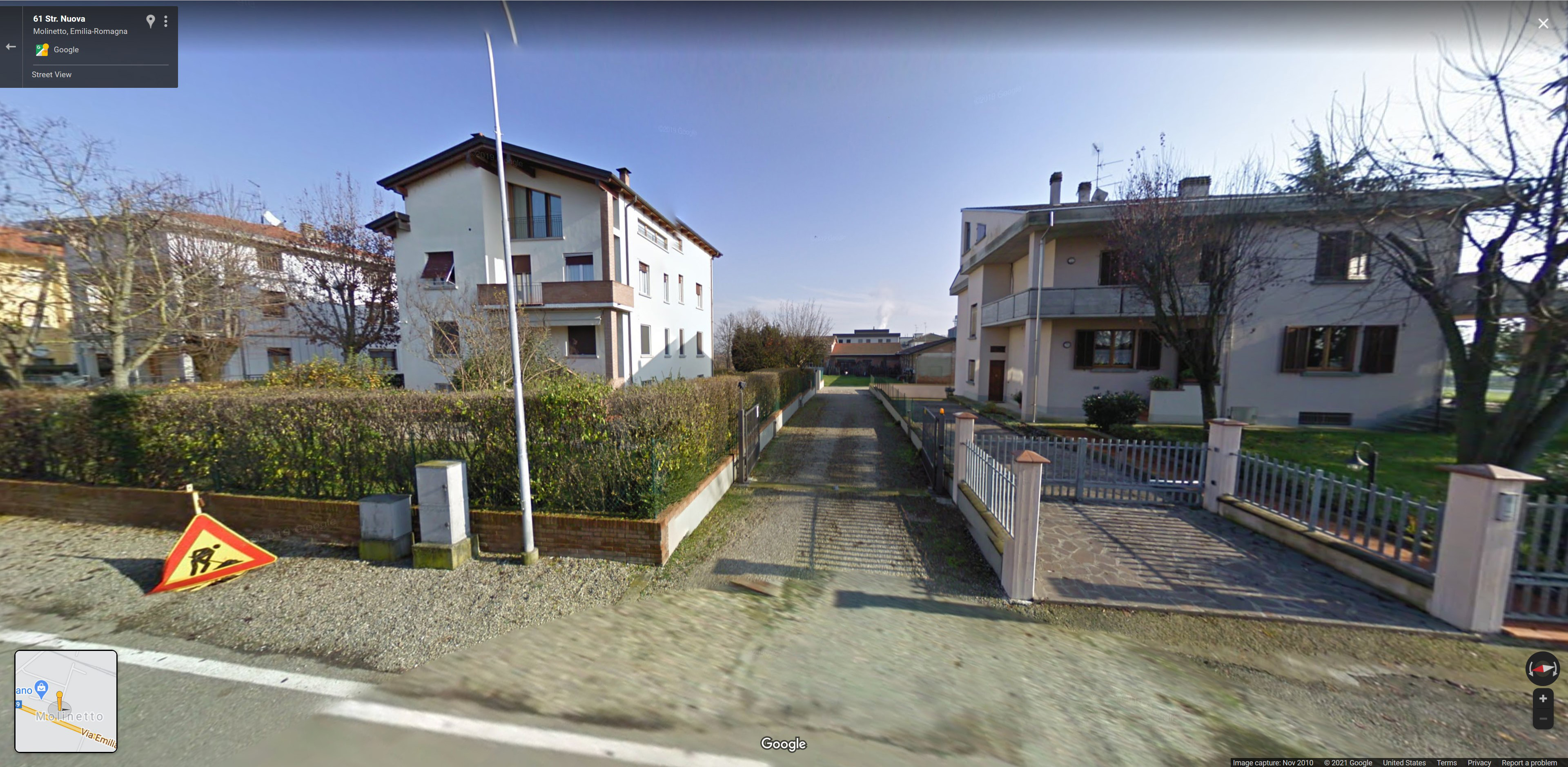
____________________
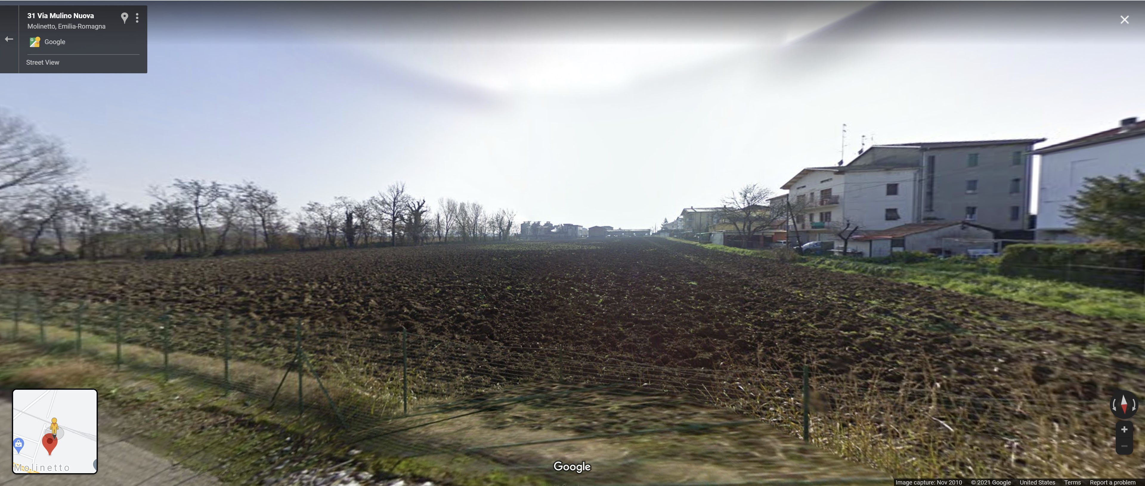
If you continue along Str. Nuova, you soon reach – just before coming to railroad tracks connecting Parma and Fidenza (and beyond) – Via Mulino Nuova, a short dead-end street oriented east-southeast. Looking south-southwest from Via Mulino Nuova presents a view directly across a patch of farmland to the rear of the former Vini-Salumi Formaggi, which is in the very center of this image.
______________________________
And so… In light of Rolland’s observations, and, air photo and street views available through Oogle, the most probable location for the crash of Ernest Willy’s Spitfire is in the vicinity of the one-story building – the former Vini-Salumi Formaggi – at the intersection of Via Emilia and Str. Nuova. If anything remains of the aircraft, it probably by now inaccessibly rests at a depth of several meters.
But, even if just a small remnant of an era which is gradually being forgotten, I would think it still exists.
Like, I hope – at least for now – memory of the pilot who flew it.
______________________________
Acknowledgement
Thanks for your help, Rolland!
References
Matzeva of Ernest Willy Rosenstein (at FindAGrave)
Casualty List in South African Jewish Times
No. 185 Squadron, RAF – history (motto (Maltese): Ara fejn hu – “Look where it is”) (at Wikipedia)
No. 185 Squadron, RAF – emblem (at RAF Heraldry Trust)
Brent, Winston, 85 Years of South African Air Force – 1920-2005, Freeworld Publications, Inc., Nelspruit, South Africa, 2005
Martin, Henry J., and Orpen, Neil, South African Forces, World War II. Vol. 6, Eagles Victorious: The Operations of the South African Forces Over the Mediterranean and Europe, in Italy, the Balkans and the Aegean, and from Gibraltar and West Africa, Purnell, Cape Town, South Africa, 1977
South African Jews in World War Two, Eagle Press, South African Jewish Board of Deputies, Johannesburg, South Africa, 1950