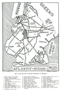
 1. Temple Beth-El of Greenpoint
2. School of Biblical Instruction
3. Ahavath Achim Synagogue
4. Temple Beth Elohim of Williamsburg (1876-1921)
5. Wallabout Bay
6. K.K. Beth Elohim Synagogue (original site)
7. Shaari Zadek Synagogue
8. Union Temple
9. Ohave Sholom Synagogue
10. Beth Israel Synagogue (1862-1902)
11. Congregation Beth Elohim
12. Baith Israel Anshei Emes (present site)
13. Congregation Mount Sinai
14. B’nai Sholaum Synaogue
15. Temple Beth-El of Borough Park
16. Temple Emanu-El of Borough Park
17. Shaare Torah Synagogue
18. Temple Beth Emeth
19. Temple Ahavath Sholom
20. Magen David Synagogue
21. Congregation Sons of Israel
22. Beth Sholom Peoples Temple
23. Brooklyn Jewish Center
24. Flatbush Jewish Center
25. Ocean Parkway Jewish Center
26. East Midwood Jewish Center
27. Jewish Community House of Bensonhurst
28. Hebrew Orphan Asylum (1892-1940)
29. Jewish Hospital
30. Beth Moses Hospital
31. Beth-El Hospital
32. Israel Zion Hospital
33. Hebrew Free School of Brownsville
34. Hebrew Educational Society
35. Hebrew Home and Hospital for the Aged
36. Jewish Sanitarium and Hospital for Chronic Diseases
37. Bikkur Cholim Synagogue
38. Temple Petach Tikvah
39. Jewish Center of Kings Highway
Tag: Brooklyn Jewish Institutions
A Changed World – Maps of Jewish Institutions of Manhattan, Brooklyn, and Chicago, in the Universal Jewish Encyclopedia, 1942
“The Map is Not the Territory” – a dictum of the Polish-American academic and creator of General Semantics, Alfred H.S. Korzybski – well embodies the concept that the map of a territory is not the territory itself.
True!
However, while by nature a map is not the territory – the place – it represents, it does represent another aspect of the world we live in: Time.
In that sense, the three maps shown in this series of blog posts, all published in the 1942 edition of Rabbi Isaac Landman’s Universal Jewish Encyclopedia, show significant landmarks and features of the world of American Jewry – in Brooklyn, Chicago, and Manhattan – as they existed three-quarters of a century ago. The maps show the location of temples, schools, Jewish communal centers, hospitals, orphanages, museums, significant historical events, newspaper and publishing houses, and headquarters of organization of varying political and ideological hues.
Doubtless, some continue to exist in 2017, perhaps even at the same locations as in 1942. Doubtless, others have moved. Doubtless, many have vanished over the seven-odd decades that have transpired since the 1940s. But, taken together as one, they provide a small window onto the nature of Jewish life in the United States in the mid-twentieth-century.
Each map is accompanied by a key, while the text of said key is transcribed beneath the map. This is especially helpful for the Manhattan map, which encompasses so very many localities.
If you desire to view the maps in greater detail than seen on your PC, Mac, or mobile device, they can be saved (right-click…) and viewed at appreciably greater size without loss of detail. (They were scanned at 400 dpi for this purpose.) This is especially so for the map of Manhattan, which – “digitally” – measures 2700 by 4400 pixels, or 7 x 11 inches. (Gadzooks.)
So, enjoy and ponder this window upon three worlds gone by!
Whether, and in what manner, those “worlds” will continue is a question which is not the subject of this post, but which is the subject of this essay by Isi Leibler…
References
Rabbi Isaac Landman (Wikipedia)
Alfred H.S. Korzybski (Wikipedia)
General Semantics (Wikipedia)
Map-Territory Relation (Wikipedia)
